Rogue River Valley, Oregon - Southern Oregon is divided into three main river basins; the Umpqua River, the Rogue River, and the Klamath Basin. The Umpqua meets the Pacific at Reedsport, the Rogue mouth is near Gold Beach, and the Klamath empties at the Redwoods National Park in Northern California. All three rivers have their headwaters in the Cascade Mountains on the slopes of Crater Lake, Oregon's only national park. The Rogue River is a designated National Scenic River, and formed much of the backdrop for the Meryl Streep movie "The River Wild." Jet boat trips and white water rafting are very popular.

Rogue River Valley

Rogue River Valley, Oregon - A beautiful place to visit, a wonderful place to live. Come and find a place to call your own. Southern Oregon is a great place to own a home and grow your family.

Rogue River Valley

Search Travel Guides
Oregon Maps
Oregon History
More Oregon History
Oregon History
More Oregon History
Pack Trains
Pack Trains II
Hydraulic Region
Floating Dredges
Quartz Mining
Quartz Mining II
Caveman Bridge
Caveman Bridge II
Josephine Platinum

Rogue River Valley - Oregon Travel Guide

Articles from the Historical Society in Josephine County Oregon


Pack Trains
1/2

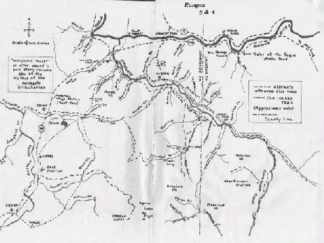
THE CRESCENT CITY TO JACKSONVILLE TRAIL
Information compiled by Willard Street

After crossing Oregon Mountain the trail crossed the west fork of the Illinois River just below the confluence of Whiskey Creek; it continued down the west fork to three quarters of a mile west of O'Brien. The trail forked here. One branch continued on the west side of the west fork to Kerby, across what is now called Sauer's Flat, up Reeves Creek, down a branch of McMullen Creek, across where Lake Selmac now is, to Samuel Mooney's donation land claim, crossed Deer Creek valley to H.W. Wixom's donation land claim. The other fork continued on to Waldo, then across Illinois Valley, crossing Althouse and Sucker Creeks, up Bear Creek (a tributary of Sucker Creek), and followed down Thompson Creek, and across Deer Creek valley to Wixom's donation land claim. From Wixom's it went up Crooks Creek, over Mooney Mountain, down Cheney Creek to the Applegate valley.

These were trails, not roads. There was no road over Mooney Mountain until 1900 when the county built the Mooney Mountain road.

By the spring of 1855, there were from 50 to 200 mules daily traveling the inland trails from the coast. Some of the stopping points were the mining communities of Waldo, Allen Town, Browntown and Kerby. Because of its strategic location on the south side of the Applegate River, Wilderville and the small community of Murphy became a major stopping point on the way to the mining communities of Williamsburg (Williams, OR) and Jacksonville to rest the animals and feed the packers. ... Continued - Page 2

Click image for larger view

Map by Willard Street

Copyright 2002-2021 TUPINC
Rogue River Valley, Oregon - The Siskiyou Mountains stretch between the Cascade Mountains and the Coast Range at the California border. The entire area is more vertical than most other parts of the state, which leads to numerous waterfalls, lots of whitewater rapids, and some spectacular scenery. Rogue River Valley is outside the main population centers of the state and the area has a very rural flavor. Major industries are tourism, wood products and agriculture. The climate is generally milder and more Mediterranean than North Western Oregon. Average rainfallis about 20 % lower and the temperatures are a bit higher.