| Rogue River Valley, Oregon - Southern Oregon is divided into three main river basins; the Umpqua River, the Rogue River, and the Klamath Basin. The Umpqua meets the Pacific at Reedsport, the Rogue mouth is near Gold Beach, and the Klamath empties at the Redwoods National Park in Northern California. All three rivers have their headwaters in the Cascade Mountains on the slopes of Crater Lake, Oregon's only national park. The Rogue River is a designated National Scenic River, and formed much of the backdrop for the Meryl Streep movie "The River Wild." Jet boat trips and white water rafting are very popular. |
Rogue River Valley |
|
|
|
Search Travel Guides Oregon Maps Oregon History More Oregon History Oregon History More Oregon History Pack Trains Pack Trains II Hydraulic Region Floating Dredges Quartz Mining Quartz Mining II Caveman Bridge Caveman Bridge II Josephine Platinum |
Rogue River Valley - Oregon Travel Guide
Articles from the Historical Society in Josephine County Oregon Hydraulic Region - Josephine County as a Hydraulic Region
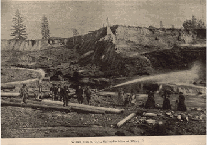
The photo is a typical placer mining operation of Josephine County's mining history.
|
| Copyright 2002-2021 TUPINC |
| Rogue River Valley, Oregon - The Siskiyou Mountains stretch between the Cascade Mountains and the Coast Range at the California border. The entire area is more vertical than most other parts of the state, which leads to numerous waterfalls, lots of whitewater rapids, and some spectacular scenery. Rogue River Valley is outside the main population centers of the state and the area has a very rural flavor. Major industries are tourism, wood products and agriculture. The climate is generally milder and more Mediterranean than North Western Oregon. Average rainfallis about 20 % lower and the temperatures are a bit higher. |